Catalina Eddy
Caption text goes here
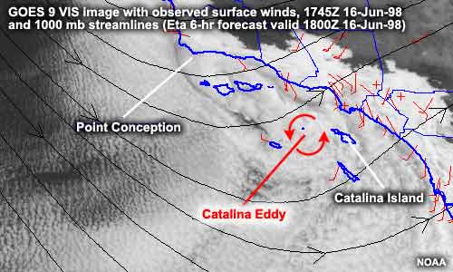
A Catalina Eddy forms when upper-level, large-scale flow off Point Conception interacts with the complex topography of the Southern California coastline. As air crosses the east-west oriented mountain ranges just east of Point Conception and descends to the ocean, the pressure on the air increases, causing it to warm dramatically. Consequently, a region of relatively low pressure develops in the lower atmosphere, with its center in the vicinity of Catalina Island. Counterclockwise circulation around this low pressure draws cool marine air and coastal stratus up the coast from the south, creating the eddy.
Catalina Eddy formation is accompanied by a southerly shift in coastal winds, a rapid increase in the depth of the marine layer, and a thickening of the coastal stratus. Catalina Eddies occur predominantly during the "stratus season," which is between April and September with a peak occurrence in June.
The effects of the Catalina Eddy on the weather over Southern California can be quite dramatic. When the Catalina Eddy is at its strongest, the depth of the low clouds may extend to 6000 feet. Usually, the increased thickness of the stratus clouds inhibits the typical morning/early afternoon burn off. Coastal temperatures will be several degrees cooler than the day before since cloud cover reduces the amount of surface heating from the sun.
Last modifed Monday, December 18, 2006.